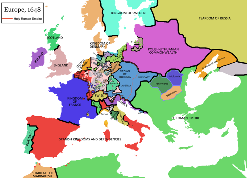
Abruozdielis:Europe map 1648.PNG

Parvaizos dėdloms: 800 × 577 pikselē. Kėtū dėdlomu: 320 × 231 pikselē | 640 × 462 pikselē | 1 024 × 739 pikselē | 1 280 × 924 pikselē | 1 894 × 1 367 pikselē.
Pradėnis abruozdielis ((1 894 × 1 367 taškū, faila dėdoms: 195 KiB, MIME tips: image/png))
Abruozdielė istuorėjė
Paspauskėt ont deinas/čiesa, ka paveizietomėt abruozdieli, kāp ons ėšruodė pradiuo.
| Dėina/Čiesos | Pamažėnėms | Mierā | Nauduotuos | Paāškėnėms | |
|---|---|---|---|---|---|
| vielībs | 12:44, 14 balondė 2021 |  | 1 894 × 1 367 (195 KiB) | Tenan | Reverted to version as of 16:09, 12 October 2017 (UTC) See discussion |
| 13:47, 9 kuova 2021 |  | 1 894 × 1 367 (210 KiB) | TTBCamh | Reverted to version as of 17:18, 20 September 2018 (UTC). I don't know why Raderich is saying this is an arbitrary change—Catalonia was under the possession of the French king in 1648, following the Catalan Revolt of 1640. This map is correct and the previous one is incorrect. | |
| 15:12, 25 siejės 2018 |  | 1 894 × 1 367 (195 KiB) | Raderich | Reverted to version as of 21:15, 18 September 2018 (UTC) Undone arbitrary changes. Revert to correct map as uploaded by its creator Roke~commonswiki | |
| 20:18, 20 siejės 2018 |  | 1 894 × 1 367 (210 KiB) | AmbroiseL | The Catalan counties were French since they proclaimed Louis XIV of France as their king. They wanted to be French in order not to obey the king of Spain anymore. Courland was a quite free vassal state of Poland. The reverted version doesn't show it. The reverted version also doesn't show the Venetian islands in the Adriatic Sea, and the Algerian towns that France occupied. Hence, I re-revert to the more precise version. | |
| 00:15, 19 siejės 2018 |  | 1 894 × 1 367 (195 KiB) | Raderich | Reverted to version as of 16:09, 12 October 2017 (UTC) | |
| 13:45, 19 lėipas 2018 |  | 1 894 × 1 367 (210 KiB) | AmbroiseL | Reverted to version as of 12:06, 20 January 2017 (UTC) — reverted to the version with fixed names, my mistake | |
| 13:37, 19 lėipas 2018 |  | 1 894 × 1 367 (150 KiB) | AmbroiseL | Reverted to version as of 10:33, 24 September 2016 (UTC) | |
| 19:09, 12 spalė 2017 |  | 1 894 × 1 367 (195 KiB) | 力 | Reverted to version as of 12:42, 9 September 2016 (UTC) why is Catalonia French? Not shown as such on File:Europe_1648_westphal_1884.jpg | |
| 15:06, 20 sausė 2017 |  | 1 894 × 1 367 (210 KiB) | Fakirbakir | Names of Austria, Bohemia and Hungary are fixed. | |
| 13:33, 24 siejės 2016 |  | 1 894 × 1 367 (150 KiB) | AmbroiseL | Adjunction of polish-lithuanian vassal state of Courland |
Abruozdieliu nauduojėms
Ons poslapis ruod ton abruozdielin:
Abruozdielė nauduojėms vėsor
Tėi viki poslapē nauduo šėton abruozdieli:
- Skvarmas nauduojėms als.wikipedia.org
- Skvarmas nauduojėms an.wikipedia.org
- Skvarmas nauduojėms ar.wikipedia.org
- Skvarmas nauduojėms ast.wikipedia.org
- Skvarmas nauduojėms azb.wikipedia.org
- Skvarmas nauduojėms bg.wikipedia.org
- Skvarmas nauduojėms bn.wikipedia.org
- Skvarmas nauduojėms br.wikipedia.org
- Skvarmas nauduojėms bs.wikipedia.org
- Skvarmas nauduojėms ca.wikipedia.org
- Skvarmas nauduojėms cs.wikipedia.org
- Skvarmas nauduojėms cy.wikipedia.org
- Skvarmas nauduojėms da.wikipedia.org
- Skvarmas nauduojėms de.wikipedia.org
- Skvarmas nauduojėms de.wikibooks.org
- Skvarmas nauduojėms el.wikipedia.org
- Skvarmas nauduojėms en.wikipedia.org
Veizietė, kāp vėsor tasā abruozdielis nauduojams īr.


