
Abruozdielis:Eyjafjallajökull.jpeg

Parvaizos dėdloms: 800 × 536 pikselē. Kėtū dėdlomu: 320 × 214 pikselē | 640 × 429 pikselē | 1 024 × 686 pikselē | 1 280 × 858 pikselē | 2 960 × 1 983 pikselē.
Pradėnis abruozdielis ((2 960 × 1 983 taškū, faila dėdoms: 3,96 MiB, MIME tips: image/jpeg))
| Tas abruozdielis īr ėš Vikitėkuos arkīvu. Anuo orėgėnalos aprašėma poslapis īr čiuonās. |
| Aprašīms |
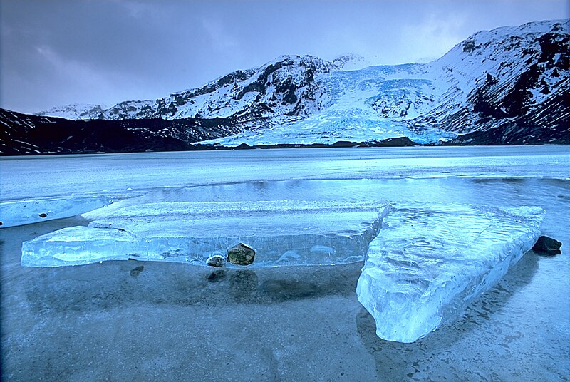
English: Gígjökull, an outlet glacier extending from Eyjafjallajökull, Iceland. Lónið is the lake visible in the foreground.
Tiếng Việt: Sông băng Eyjafjallajökull tại Iceland.
Photo was taken using the following technique:
|
||
| Čiesos | 2003-02-13, 11:00–12:00 | ||
| Šaltėnis |
Patėis darbs: http://fam-tille.de/sparetime.html |
||
| Kūries | Andreas Tille | ||
| Laidėms (Abruozdielė parnauduojėms) |
Quote of http://fam-tille.de/island/winter/0213/2003_093.html - Permission is granted to copy, distribute and/or modify this images under the terms of the GNU Free Documentation License, Version 1.1 or any later version published by the Free Software Foundation. Aš, šio darbo autoriaus teisių savininkas, publikuoju jį su šiomis licencijomis:
Šiam failui taikomos Creative Commons Attribution-Share Alike 3.0 Unported, 2.5 Generic, 2.0 Generic bei 1.0 Generic licencijos.
Pasėrinkat vėina ėš tū lėcencėju. |

| Fotografijos koordinatės | | Šis ir kiti paveikslėliai: OpenStreetMap |
|---|
| Annotations | This image is annotated: View the annotations at Commons |
Assessment
|
This image was selected as picture of the day on Wikimedia Commons for 21 December 2004. It was captioned as follows: Other languages:
Esperanto: Glaciejo Eyjafjallajökull en Islando |
This image was selected as picture of the day on Vietnamese Wikipedia.
|
Abruozdielė istuorėjė
Paspauskėt ont deinas/čiesa, ka paveizietomėt abruozdieli, kāp ons ėšruodė pradiuo.
| Dėina/Čiesos | Pamažėnėms | Mierā | Nauduotuos | Paāškėnėms | |
|---|---|---|---|---|---|
| vielībs | 15:01, 2 groudė 2004 | | 2 960 × 1 983 (3,96 MiB) | Ævar Arnfjörð Bjarmason |
Abruozdieliu nauduojėms
Abruozdielėp neruod anėjuoks poslapis.
Abruozdielė nauduojėms vėsor
Tėi viki poslapē nauduo šėton abruozdieli:
- Skvarmas nauduojėms af.wikipedia.org
- Skvarmas nauduojėms an.wikipedia.org
- Skvarmas nauduojėms arc.wikipedia.org
- Skvarmas nauduojėms ar.wikipedia.org
- Skvarmas nauduojėms arz.wikipedia.org
- Skvarmas nauduojėms azb.wikipedia.org
- Skvarmas nauduojėms be.wikipedia.org
- Skvarmas nauduojėms bg.wikipedia.org
- Skvarmas nauduojėms bg.wikinews.org
- Skvarmas nauduojėms bo.wikipedia.org
- Skvarmas nauduojėms br.wikipedia.org
- Skvarmas nauduojėms bs.wikipedia.org
- Skvarmas nauduojėms ca.wikipedia.org
- Skvarmas nauduojėms co.wikipedia.org
- Skvarmas nauduojėms cs.wikipedia.org
- Skvarmas nauduojėms da.wikipedia.org
- Skvarmas nauduojėms de.wikipedia.org
- Eisscholle
- Benutzer:Rainbowfish/Test10
- Wikipedia:Kandidaten für exzellente Bilder/Archiv2005/7
- Wikipedia:Archiv/Hilfe:MediaWiki/Versionen
- Benutzer:Torinberl/Testterrain
- Benutzer:Torinberl/Benutzerseite
- Portal Diskussion:Island/Bild des Monats
- Benutzer Diskussion:Placebo111
- Portal Diskussion:Island/Bild des Monats/Archiv/2006
- Benutzer:Rainbowfish/Bilder
- Benutzer:Rainbowfish/ALT
- Portal Diskussion:Vulkane/Vulkanbild der Woche
- Skvarmas nauduojėms de.wiktionary.org
- Skvarmas nauduojėms dsb.wikipedia.org
- Skvarmas nauduojėms el.wikipedia.org
- Skvarmas nauduojėms en.wikipedia.org
Veizietė, kāp vėsor tasā abruozdielis nauduojams īr.