
Abruozdielis:NASA-Apollo8-Dec24-Earthrise.jpg

Parvaizos dėdloms: 600 × 600 pikselē. Kėtū dėdlomu: 240 × 240 pikselē | 480 × 480 pikselē | 768 × 768 pikselē | 1 024 × 1 024 pikselē | 2 400 × 2 400 pikselē.
Pradėnis abruozdielis ((2 400 × 2 400 taškū, faila dėdoms: 945 KiB, MIME tips: image/jpeg))
| Tas abruozdielis īr ėš Vikitėkuos arkīvu. Anuo orėgėnalos aprašėma poslapis īr čiuonās. |
Paāškėnėms
| Bill Anders: Earthrise
|
|||||||||||||||||||||||||||
|---|---|---|---|---|---|---|---|---|---|---|---|---|---|---|---|---|---|---|---|---|---|---|---|---|---|---|---|
| Kūries |
NASA/Bill Anders |
 | |||||||||||||||||||||||||
| Fotografas |
|
||||||||||||||||||||||||||
| Pavadinimas |
Earthrise |
||||||||||||||||||||||||||
| Object type |
fotografija |
||||||||||||||||||||||||||
| Aprašīms |
العربية: التُقطت هذه الصُورة من قِبل أحد أعضاء طاقم أپولو 8 المدعو بيل آندرس يوم 24 كانون الأوَّل (ديسمبر) سنة 1968، بِتوقيت المُهمَّة 075:49:07 [1] (16:40 ت ع م)، بينما كان الطاقم يدور في مدار القمر، وهي تُظهرُ شُرُوق الأرض لِلمرَّة الثالثة فوق أُفق القمر. يبعد الأُفق القمري كيلومترًا عن المركبة الفضائيَّة. يبلغ عرض المنطقة المُصوَّرة عند الأُفق الأخير حوالي 175 كيلومترًا. [2] اليابسة الظاهرة فوق خط الأُفق بِقليل هي أفريقيا الغربيَّة. لاحظ أنَّ هذه الظاهرة مرئيَّة فقط لِلناظر المُتحرِّك بِالنسبة لِسطح القمر. بِسبب دوران القمر المُتزامن مع دوران الأرض (أي أنَّ وجه القمر المُوجه لِلأرض يبقى هو نفسه)، فإنَّ الأرض تبدو وكأنها ثابتة (تُقاسُ بِأيِّ وحدةٍ أقل من الوحدة الزمنيَّة الجيولوجيَّة) في «سماء» القمر. في سبيل مُشاهدة تأثير شُرُوق وغُروب الأرض خلف أُفق القمر، على الناظر أن يتوجَّه نحو، أو يبتعد عن، نُقطة سطح القمر التي تعلوها الأرض مُباشرةً (في وسط السماء). وإلَّا، فإنَّ الحركة الظاهريَّة لِلأرض ومنظرها المرئيّ سيتبدَّل ويقتصر على: 1. ازدياد أو تناقص حجمها باختلاف المسافة الفلكيَّة بين الجرمين السماويين. 2. الحركة الظاهريَّة البسيطة لِلأرض بِسبب الشُذوذ المداري لِلقمر، يُسمَّى هذا التأثير ميسانًا. 3. دوران الأرض (دورانُ القمر مُتزامنٌ مع دوران الأرض، أمَّا دوران الأرض فليس مُتزامنًا مع دوران القمر). 4. التغيُّرات الجويَّة والسطحيَّة على الأرض (مثلًا: الأنماط المُناخيَّة، المواسم المُتعاقبة، إلخ.).
Беларуская (тарашкевіца): Фатаздымак, зроблены астранаўтам «Апалёну-8» Білам Андэрзам ранкам 24 сьнежня 1968 року а 075:49:07 з пачатку палёту [3] (16:40 UTC), на арбіце вакол Месяца, паказвае трэці ўзыход Зямлі над месячным гарызонтам. Месячны гарызонт знаходзіцца прыкладна за 780 км ад касьмічнага карабля. Шырыня сфатаграфаванага абшару на месячным гарызонце — каля 175 км [4]. Кавалак зямлі, бачны адразу над лініяй сьветападзелу — заходняя Афрыка. Зьвярніце ўвагу, што такі эфэкт бачны толькі такому назіральніку, які знаходзіцца ў руху адносна паверхні Месяцу, бо Месяц круціцца сынхронна адносна Зямлі (Месяц заўсёды павернуты да Зямлі адным бокам), і з-за гэтага Зямля на месячным «небе» падаецца нерухомай (ня ўлічваючы часавага прасьцягу геалягічных маштабаў). Каб убачыць эфэкт узыходу ці заходу Зямлі над месячным гарызонтам, назіральнік мусіць перамясьціцца ўперад ці ўзад ад кропкі на паверхні Месяцу, дзе Зямля знаходзіцца над самай галавой (па цэнтры неба). Іначай бачны рух/зьмена становішча Зямлі будзе абмежаваная: 1. Павелічэньнем/памяншэньнем памеру пры зьмяненьні адлегласьці між двума нябёснымі целамі. 2. Драбнюткім заўважным зьмяшчэньнем Зямлі з прычыны эксцэнтрысытэту арбіты Месяцу — эфэкту пад назвай «хістаньне». 3. Кручэньнем Зямлі (кручэньне Месяцу сынхроннае адносна Зямлі, а кручэньне Зямлі не сынхроннае адносна Месяцу). 4. Атмасфэрным і паверхневым зьмяненьнямі на Зямлі (напрыклад: мадэлямі надвор’я, зьмяненьнем пораў году й інш.). Двум кратэрам, бачным на здымку, Міжнародны астранамічны зьвяз у 2018 року прысвоіў найменьні 8 Homeward і Anders' Earthrise у гонар місіі «Апалёну-8»[5].
Čeština: Fotografie z povrchu Měsíce zdánlivě zapadající Země byla pořízená členem posádky Apolla 8 Billem Andersem 24. prosince 1968. cv
Udah bumi bumi udah selesai di bulan 🌒🌙 pl Ελληνικά: Τραβηγμένη απο τον Μπιλ 'Αντερς, μέλος του πληρώματος του διαστημοπλοίου Απόλλων 8 στις 24 Δεκεμβρίου, 1968 στις 075:49:07 ώρα αποστολή [6] (16:40 UTC) εν'όσω βρίσκονται σε τροχιά γύρω απο την Σελήνη, παρουσιάζει την Γη να ανατέλει για τρίτη φορά στον Σεληνιακό ορίζοντα. Ο Σεληνιακός ορίζοντας βρίσκεται περίπου 780 χιλιόμετρα μακρία απο το διαστημόπλοιο. Το ύψος της φωτογράφημένης περιοχής του σεληνιακού ορίζοντα είναι περίπου 175 χιλιόμετρα. [7]. Η μάζα γης που είναι ορατή πάνω ακριβώς απο την τελική γραμμή ειναι η δυτική Αφρική. Να σημειωθεί πως αυτό το φαινόμενο ειναι ορατό απο έναν παρατηρητή μόνο σε σχετική κίνηση με την επιφάνεια της Σελήνης. Εξαιτίας της συγχρονισμένης Σεληνιακής περιστροφής σχετικά με την Γη (πχ, η ίδια πλευρά της Σελήνης είναι πάντα ορατή στην Γη), η Γη φαίνεται σαν να είναι στατική στον σεληνιακό ουρανό.
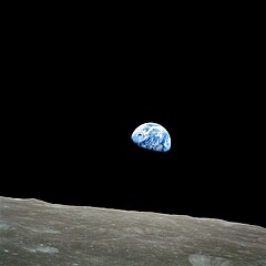
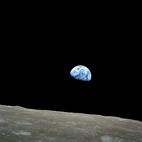
English: Taken by Apollo 8 crewmember Bill Anders on December 24, 1968, at mission time 075:49:07 [8] (16:40 UTC), while in orbit around the Moon, showing the Earth rising for the third time above the lunar horizon. The lunar horizon is approximately 780 kilometers from the spacecraft. Width of the photographed area at the lunar horizon is about 175 kilometers. [9] The land mass visible just above the terminator line is west Africa. Note that this phenomenon is only visible to an observer in motion relative to the lunar surface. Because of the Moon's synchronous rotation relative to the Earth (i.e., the same side of the Moon is always facing Earth), the Earth appears to be stationary (measured in anything less than a geological timescale) in the lunar "sky". In order to observe the effect of Earth rising or setting over the Moon's horizon, an observer must travel towards or away from the point on the lunar surface where the Earth is most directly overhead (centred in the sky). Otherwise, the Earth's apparent motion/visible change will be limited to: 1. Growing larger/smaller as the orbital distance between the two bodies changes. 2. Slight apparent movement of the Earth due to the eccenticity of the Moon's orbit, the effect being called libration. 3. Rotation of the Earth (the Moon's rotation is synchronous relative to the Earth, the Earth's rotation is not synchronous relative to the Moon). 4. Atmospheric & surface changes on Earth (i.e.: weather patterns, changing seasons, etc.). Two craters, visible on the image were named 8 Homeward and Anders' Earthrise in honor of Apollo 8 by IAU in 2018. (Press release). The NASA image number is AS08-14-2383.
Español: "Amanecer de la Tierra" desde la luna. Foto tomada el 24 de diciembre de 1968 por Bill Anders, que muestra la tierra que parece elevarse detrás del horizonte lunar. Este fenómeno es visible solo por alguien que orbita el astro. Debido a la rotación sincrónica de la luna, que siempre muestra la misma cara hacia la tierra, no vemos que la tierra se eleve o se extienda desde la superficie de la luna.
Français : "Lever de terre" sur la lune. Photo prise le 24 décembre 1968 par Bill Anders, et montrant la terre semblant se lever derrière l'horizon lunaire. Ce phénomène n'est visible que par quelqu'un en orbite autour de l'astre. A cause de la rotation synchrone de la lune, qui montre toujours la même face vers la terre, on ne voit pas la terre se lever ou se coucher depuis la surface de la lune.
Magyar: „Földfelkelte” a Holdról 1968. december 24-én, Bill Anders, az Apollo 8 űrhajósának képén. Valódi „földfelkeltét” csak az láthat, aki kering a Hold körül, mert a Hold egy adott pontjáról nézve a Föld az égnek folyamatosan ugyanazon a részén látszik (megfordítva: a Földről a Holdnak mindig és mindenhol (megközelítőleg) ugyanaz a fele látszik). A Föld forgása, illetve a napfényes részének változása viszont a Hold felszínéről is látszik.
Русский: Фото, полученное Уильямом Андерсом, пилотом корабля «Аполлон-8» 24 декабря, 1968, показана видимая часть Земли, поднимающаяся над лунной поверхностью. Заметим, что это явление видимо только на некоторых орбитах Луны. Из-за синхронного вращения Луны вокруг Земли (т.е. та же сторона Луны всегда обращена к Земле), восход Земли над линией горизонта (Earthrise) нельзя наблюдать ни в какой точке Луны. |
||||||||||||||||||||||||||
| Čiesos | Taken on 1968 m. groudė 24 d., 16:40 UTC[10] | ||||||||||||||||||||||||||
| Kolekcija |
|
||||||||||||||||||||||||||
| Pastabos |
Taken on 70-mm Ektachrome film magazine with modified Hasselblad 500EL camera (pictured below) and lens with 250-mm focal length. Exposure time is 1/250 of a second, focus setting is f/11. [11] Lunar coordinates are 110 km (68 miles, 60 nautical miles) above 11.2°S 113.8°E. [12] |
||||||||||||||||||||||||||
| Riferimenti |
100 Photographs: The Most Influential Images of All Time |
||||||||||||||||||||||||||
| Šaltėnis | http://www.hq.nasa.gov/office/pao/History/alsj/a410/AS8-14-2383HR.jpg | ||||||||||||||||||||||||||
| Kitos versijos |
Other versions:
Derivative works: |
||||||||||||||||||||||||||

.jpg)
.jpg)


This image or video was catalogued by Johnson Space Center of the United States National Aeronautics and Space Administration (NASA) under Photo ID: AS08-14-2383. This tag does not indicate the copyright status of the attached work. A normal copyright tag is still required. See Commons:Licensing. Other languages:
|
|
This image was selected as picture of the day on Wikimedia Commons for 26 April 2009. It was captioned as follows: English: Taken by Apollo 8 crewmember Bill Anders on December 24, 1968, showing the Earth seemingly rising above the lunar surface. Note that this phenomenon is only visible from someone in orbit around the Moon. Because of the Moon's synchronous rotation about the Earth (i.e., the same side of the Moon is always facing the Earth), no Earthrise can be observed by a stationary observer on the surface of the Moon. Other languages:
Čeština: Vycházející Země, jak ji 24. prosince 1968 vyfotografoval Bill Anders, člen posádky Apolla 8 na oběžné dráze Měsíce Dansk: Billede af en tilsyneladende "jordopgang" på Månen, taget 24. december 1968 af astronauten William Anders under Apollo 8-missionen. Dette fænomen kan kun ses fra kredsløb om Månen, fordi Månen har bunden rotation og altid vender samme side mod Jorden, så Jorden ikke kan ses "stå op" ved betragtning fra Månens overflade. Deutsch: Die aufgehende Erde, aufgenommen während der Mondumkreisung von Apollo 8 im Jahr 1968. Auf der Erde durchquert die Tag-Nacht-Grenze gerade Afrika. Der Erdaufgang als solches ist nur aus einem Raumschiff in der Mondumlaufbahn zu beobachten. Da der Mond selbst der Erde wegen der gebundenen Rotation stets die gleiche Seite zuwendet, ist die Erde von der Mondoberfläche entweder stets oder nie sichtbar. English: Taken by Apollo 8 crewmember Bill Anders on December 24, 1968, showing the Earth seemingly rising above the lunar surface. Note that this phenomenon is only visible from someone in orbit around the Moon. Because of the Moon's synchronous rotation about the Earth (i.e., the same side of the Moon is always facing the Earth), no Earthrise can be observed by a stationary observer on the surface of the Moon. Español: Fotografía tomada el 24 de diciembre de 1968 desde el Apolo 8 mostrando la Tierra aparentemente saliendo sobre la superficie lunar. Adviértase que este fenómeno solo es visible para alguien en órbita alrededor de la Luna. Français : "Lever de Terre" sur la Lune. Photo prise le 24 décembre 1968 par Bill Anders (membre de l'équipe d'Apollo 8), et montrant la terre semblant se lever derrière l'horizon lunaire. Ce phénomène n'est visible que par quelqu'un en orbite autour de l'astre. A cause de la rotation synchrone de la lune, qui montre toujours la même face vers la terre, on ne voit pas la terre se lever ou se coucher depuis la surface de la lune. Nederlands: Earthrise (de opkomende aarde), genomen tijdens de bemande ruimtevaartmissie van de Apollo 8 in 1968. Op de Aarde doorloopt de dag-nachtgrens door het continent Afrika. De aardopgang is alleen te zien vanuit een ruimtevaartuig in een baan rond de maan. Aangezien de maan vanwege zijn gebonden rotatie altijd met dezelfde zijde naar de Aarde is gekeerd (voorzijde van de maan), is de Aarde vanaf het maanoppervlak ofwel helemaal of helemaal niet zichtbaar. De foto wordt beschouwd een van de beroemste allertijden en werd door astronaut William (Bill) Anders eigenlijk verticaal genomen met het maanoppervlak aan rechterzijde. In reproducties wordt de foto echter meestal omgedraaid zodat de Aarde boven komt te staan. Polski: Zdjęcie wschodzącej Ziemi wykonane 24 grudnia 1968 roku z orbity okołoksiężcowej przez Williama Andersa, pilota modułu księżycowego statku Apollo 8 Română: Imagine realizată de membrul misiunii Apollo 8, Bill Anders, la 24 decembrie 1968, și care prezintă Pământul răsărind deasupra suprafeței lunare. Acest fenomen este vizibil doar cuiva aflat pe orbita Lunii. Din cauza rotației Lunii, sincronă cu cea a Pământului, Luna are o singură față îndreptată spre Pământ, și de pe suprafața Lunii nu se vede niciun răsărit al Pământului. Македонски: Фотографија на космонаутот Бил Андерс од Аполо 8 направена на 24 декември, 1968, на која Земјата привидно „изгрева“ над површината на Месечината. Овој феномен е видлив само за оној кој орбитира околу Месечината. Бидеќи Месечината се врти рамномерно со вртењето на Земјата (т.е. истата страна на Месечината секогаш гледа во истата страна на Земјата), неможно е од самата површина на Месечината да се види изгрев на Земјата. Русский: Фото, полученное Уильямом Андерсом, пилотом корабля «Аполлон-8» 24 декабря, 1968, показана видимая часть Земли, поднимающаяся над лунной поверхностью. Заметим, что это явление видимо только на некоторых орбитах Луны. Из-за синхронного вращения Луны вокруг Земли (т.е. та же сторона Луны всегда обращена к Земле), восход Земли над линией горизонта (Earthrise) нельзя наблюдать ни в какой точке Луны. 한국어: 아폴로 8호의 승무원 빌 앤더스가 1968년 12월 24일 달 표면 위로 떠오른 것처럼 보이는 지구의 모습을 찍은 사진. 이 현상은 달의 궤도 상에서만 보이는데, 달이 지구와 동시에 돌고 있기 때문에 (지구에서 언제나 달의 같은 면만 보이는 이유) 달의 표면에서 지구돋이를 보는 것은 사실상 불가능하다. 中文: 阿波罗8号成员威廉·安德斯拍摄于1968年12月24日,展现了地球从月亮的表面升起的景观。这一现象只能在绕月的轨道上看到。因为月亮和地球同步旋转(面向地球的总是月亮的同一面),在月亮的表面上观看不到地球升起。 中文(繁體): 地球看似從月球表面升起的景象。這一現象只能在繞月的軌道上看到。因為月亮和地球同步旋轉,即面向地球的總是月亮的同一面,在月亮的表面上觀看不到地球升起。照片由阿波羅8號機務人員威廉·安德斯於1968年12月24日拍攝。 עברית : תמונה שצולמה על ידי ביל אנדרס באפולו 8 ב-24 בדצמבר 1968 המראה את כדור הארץ הזורח מעל פני הירח. תופעה זו נצפית רק כשנמצאים במסלול סביב הירח. בגלל תנועתו הסינכרונית של הירח סביב הארץ (כלומר אותו הצד של הירח כל הזמן מופנה כלפי כדור הארץ), לא ניתן לצפות בזריחה של הארץ מעל הירח מפני השטח של הירח. العربية : الأرض كما تظهر من القمر فارسی : تصویر زمین از ماه گرفته شده توسط ماموریت فضایی آپولو ۸ |

|
This is one of the images forming part of the Valued image set: Earth from space on Wikimedia Commons. The image set has been assessed under the valued image set criteria and is considered the most valued set on Commons within the scope:
You can see its nomination at Commons:Valued image candidates/Earth from space. |
Lėcencėjė
| Šis failas licencijuojamas viešajam naudojimui, nes jis buvo sukurtas NASA. NASA autorinių teisių taisyklės nurodo, kad „NASA medžiaga nėra saugoma autorinių teisių, išskyrus pažymėtą“ (NASA autorių teisių taisylės arba JPL paveikslėlių naudojimo tvarka). | ||
 |
Įspėjimai:
|
| Annotations | This image is annotated: View the annotations at Commons |
Abruozdielė istuorėjė
Paspauskėt ont deinas/čiesa, ka paveizietomėt abruozdieli, kāp ons ėšruodė pradiuo.
| Dėina/Čiesos | Pamažėnėms | Mierā | Nauduotuos | Paāškėnėms | |
|---|---|---|---|---|---|
| vielībs | 00:26, 5 kuova 2022 | | 2 400 × 2 400 (945 KiB) | Aaron1a12 | Sharper source |
| 01:26, 15 rogpjūtė 2019 |  | 2 400 × 2 400 (304 KiB) | Earthsound | Reverted to version as of 11:55, 18 July 2019 (UTC): Don't overwrite files that have been awarded a special status, especially when they're edited differently | |
| 16:15, 18 lėipas 2019 |  | 3 000 × 3 000 (483 KiB) | The NMI User | Reverted to version as of 11:41, 18 July 2019 (UTC) | |
| 14:55, 18 lėipas 2019 |  | 2 400 × 2 400 (304 KiB) | The NMI User | Reverted to version as of 02:26, 3 September 2005 (UTC) | |
| 14:41, 18 lėipas 2019 |  | 3 000 × 3 000 (483 KiB) | The NMI User | Higher res | |
| 05:26, 3 siejės 2005 |  | 2 400 × 2 400 (304 KiB) | Saperaud~commonswiki | Taken by Apollo 8 crewmember Bill Anders on December 24, 1968, showing the Earth rising above the lunar surface. Source: http://www.hq.nasa.gov/office/pao/History/alsj/a410/as8-14-2383HR.jpg ; original upload english wikipedia 2 April 200 |
Abruozdieliu nauduojėms
Ons poslapis ruod ton abruozdielin:
Abruozdielė nauduojėms vėsor
Tėi viki poslapē nauduo šėton abruozdieli:
- Skvarmas nauduojėms ab.wikipedia.org
- Skvarmas nauduojėms ace.wikipedia.org
- Skvarmas nauduojėms ady.wikipedia.org
- Skvarmas nauduojėms af.wikipedia.org
- Skvarmas nauduojėms ang.wikipedia.org
- Skvarmas nauduojėms anp.wikipedia.org
- Skvarmas nauduojėms an.wikipedia.org
- Skvarmas nauduojėms arc.wikipedia.org
- Skvarmas nauduojėms ar.wikipedia.org
- القمر
- أبولو 8
- وليام أندرس
- شروق الأرض
- ويكيبيديا:صور مختارة/الفضاء والكون/نظرة إلى الخلف
- بوابة:علم الفلك/صورة مختارة
- سماء خارج الأرض
- ويكيبيديا:ترشيحات الصور المختارة/شروق الأرض
- ويكيبيديا:صورة اليوم المختارة/يونيو 2017
- قالب:صورة اليوم المختارة/2017-06-01
- بوابة:علم الفلك/صورة مختارة/26
- الأرض من سفينة الفضاء
- قائمة الصور الأيقونية
- التاريخ العظيم
- تراث الإنسانية المشترك
- طور أرضي
- ويكيبيديا:صورة اليوم المختارة/أكتوبر 2021
- قالب:صورة اليوم المختارة/2021-10-15
- Skvarmas nauduojėms ast.wikipedia.org
- Skvarmas nauduojėms avk.wikipedia.org
- Skvarmas nauduojėms av.wikipedia.org
- Skvarmas nauduojėms awa.wikipedia.org
- Skvarmas nauduojėms ay.wikipedia.org
- Skvarmas nauduojėms azb.wikipedia.org
- Skvarmas nauduojėms az.wikipedia.org
- Skvarmas nauduojėms ban.wikipedia.org
- Skvarmas nauduojėms ba.wikipedia.org
- Skvarmas nauduojėms bcl.wikipedia.org
- Skvarmas nauduojėms be.wikipedia.org
Veizietė, kāp vėsor tasā abruozdielis nauduojams īr.